
A little thought on AI

For more hands-on articles, please visit my new home of writing at 👉 vocus . In the evolving landscape of AI and large language models (LLMs), the ability to synthesise diverse pieces of knowledge is becoming increasingly crucial. It's no longer just about the information one accumulates but about grasping the underlying concepts that thread this information together into a cohesive, innovative framework.  A pivotal factor here is an individual's comprehension of 'connector words' or key concepts that bridge various domains of knowledge, facilitating groundbreaking insights and developments. In this scenario, learning skills are becoming more vital than ever before. It heralds an opportune moment to carve out one's niche in the AI-dominated future, a time to decide the role one wishes to play in this unfolding narrative.  Do you aspire to be a visionary, harnessing AI's potential to catapult humanity to uncharted territories, perhaps even fostering space colo

Hiking 🏔️ 風櫃嘴 - 擎天岡 Fengguizui - Qingtiangang

the view from the trail
Not sure what the name of the small island is 🤔
 
久沒發文,單純發現這條路線不好計劃如果是預計搭乘交通工具,所以想留些紀錄。不管是從風櫃嘴到擎天岡或是相反走法,從風櫃嘴上山或下山的班次都不多,雖然選擇了如標題的所示的路線,也因當天是個大好天氣,參雜了疫情漸降的連假假期的因素,在故宮下的外雙溪站轉接 M1 (市民小巴1)上山也是等到了第三班才上得了車。


等到的第三班 M1 是加班車,我想也許是假日遊客眾多的關係,後來發現其實是可以先使用台北市預約公車的,如果是可以預測到上山遊客會較多的連續假日,也不失個好備案。於是乎利用google maps規劃路線以及bus+查詢公車時刻 (單純因為UI不傷眼),大概就是利用公車走跳台北市最佳工具了。

從擎天岡下山倒是簡單些,在遊客較多的假日,頂多就是排隊等待,總是會把人潮消化完。偶爾會碰到熱心的司機小哥,提供接駁到冷水坑,等待載客較多的大車,也是有趣的經驗。

講完交通,這條路線原先比較期待的是在頂山前後的人造柳杉林。這片日治時期留下的人造林,的確可以感受到高海拔林相的清爽幽靜,一瞬間聯想到了翠峰湖步道那片山毛櫸原始林,但少了人們的大聲喧嚷跟帶上山的喇吧我想會更好;只是這也無可厚非,假日上山需做的妥協。在石梯嶺步道附近的大草原也讓我頓時一閃,「喔~在陽明山上露營應該就是這種感覺與視野」。

總長約7公里的路線,雖說風很大,但毫不留情的陽光直曬還是覺得蠻累的。用Relive記錄的路線影片做個ending。未來這個網誌將會放一些輕鬆愉快的話題,也計劃另外再架一個JAMstack網站,分享一些關於網路開發、UX、WebGL、Web3 (I hope)的projects和實驗。

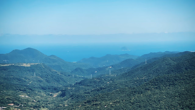
It is impossible not to fall in love with hiking if you live in Taipei. It might sound a little bit of exaggeration but there is a reason you might find it is actually reasonable. Surrounded by volcanic landscapes, lush forests, and striking coastlines, many hiking trails out there are waiting for exploration, and thanks to the convenient public transportation, they are rather approachable. Around 1-2 hours you can switch the sensation from a city-mode to a nature-mode, I think it's the best way to balancing a busy life. 

I initially chose to start the trail from the Fengguizui due to the bus schedule is not flexible as from Qingtiangang. It's true in many cases, but be noticed when you plan to go on weekends, you may or may not have additional buses for distributing the long queues of passengers, and need to wait for several rounds to get on a bus eventually. In my case, I got on the M1 (from Waishuang River to Fengguizui) till the third-round additional bus.

A workaround I found is that you can reserve the bus ahead on  Taipei Bus Reservation System especially on weekends. Although Google Maps is always a good friend to plan a road trip, when it comes to bus schedules I think the bus+ is a good app if you want to know when the bus will arrive.

The hiking from Fengguizui to Qingtiangang ended up being good. I recorded my route with Relive hope it will give you a much clearer image of the trail. 


Comments

  1. 好懷念的遊記文章喔!沒想到blog也有了復古感,不知道10年後的網路社群會發展成什麼模樣。

    ReplyDelete
    Replies
    1. 其實蠻想關掉的,畢竟一直也都沒很認真在經營。但 google近幾年也改版blogger不少,也算方便可以寫些東西,塞一點css和js,還算堪用。希望新的網站可以帶給大家不同的內容和體驗... 也期待看到你的新作品 🥰

      Delete
  2. 這樣記錄旅行真好,來你這總像是開窗,這次窗後的景是十多年沒見的擎天岡

    ReplyDelete
    Replies
    1. 謝謝這麼美的形容,對產出內容的人來說真的是一個莫大的動力 ☺️

      Delete

Post a Comment

Popular posts from this blog

手工黑白沖片

從「我在墾丁天氣晴」開始